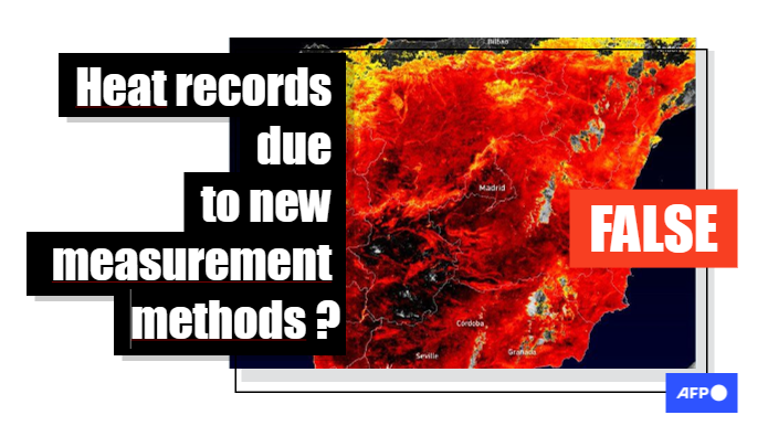
This summer saw many regions of the northern hemisphere experience extreme heat for long durations, including the United States, southern Europe, north Africa and China.
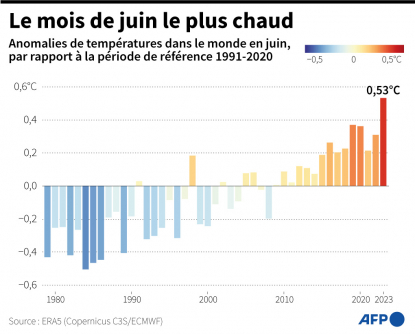
In fact, July 2023 was the hottest month ever recorded on Earth, according to the EU’s climate monitoring service Copernicus.
Experts and UN have pointed to the link between these heatwaves and climate change, yet some social media argued instead that the temperature increase was due to a change in methodology.
“The heat records have been ‘shattered’ because the ESA has begun to use land surface temperatures instead of air temperatures,” someone posted to X (formerly Twitter) on July 20, earning more than 2,000 retweets.
The allegation was also made on Facebook: “This is how the ghouls (globalists) manipulate temperature readings to make you believe their lies”.
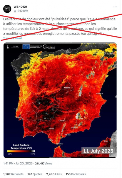
Many internet users made reference to Climate Science Journal’s July 14 reply on X to a tweet from Swedish climate activist Greta Thunberg.

Based in London, Climate Science Journal describes itself as a site that is all “about restoring integrity to the study of climate change” and challenging the greenhouse gas theory, which it calls “pseudo-science”.
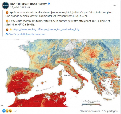
This organisation, and those who shared its message in French, cited a post from the ESA that it published to its website as well as on X and Facebook on July 13, 2023.
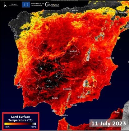
Many of the posts also featured a map, which Copernicus had posted on July 12 to go along with an article on the heatwave.
What do ESA and Copernicus say?
On July 12, Copernicus’s website devoted its “image of the day” to the heatwave. It featured a map of Spain from the previous day showing the land surface temperature measured in Celsius. Several areas were in grey, indicating temperatures around 60 degrees Celsius.
Alongside the map was an article entitled “Scorching heatwave hits Spain”.
“On 11 July 2023, the Land Surface Temperature (LST) in some areas of Extremadura (Spain) exceeded 60°C, as highlighted in this data visualisation derived from measurements from the Copernicus Sentinel-3 Sea and Land Surface Temperature Radiometer (SLSTR) instrument,” the article explained.
“The ongoing heatwave in Spain this week is resulting in a total of 13 autonomous communities, being at extreme risk (red alert), significant risk (orange alert), and risk (yellow alert) due to maximum temperatures that, in some cases, will exceed 40°C and reach a maximum of 43°C,” it added.
A disclaimer at the end cautioned that “the LST is the temperature of the soil and should not be confused with air temperature.”
The following day, the ESA published its own article on the heatwave. The agency is in charge of a space component of the Copernicus programme and uses a constellation of satellites dubbed “Sentinels”. One of them is equipped with a radiometer for measuring land surface temperature.
In its article entitled “Europe braces for sweltering July”, the ESA mentioned both air and land surface temperature.
“The highest temperature in European history was broken on 11 August 2021, when a temperature of 48.8°C was recorded in Floridia, an Italian town in the Sicilian province of Syracuse. That record may be broken again in the coming days,” the ESA wrote.
“In some cities the surface of the land exceeded 45°C, including Rome, Naples, Taranto and Foggia. Along the east slopes of Mount Etna in Sicily, many temperatures were recorded as over 50°C,” it added.
“The heatwave is also hitting other cities across Europe with air temperatures expected to reach 44°C in parts of Spain later this week. A wider view of Europe can be seen in the image below. Land surface temperatures hit 46°C in Rome, Italy, while Madrid and Seville in Spain reached 46°C and 47°C, respectively.”
The article went on to explain the difference between the two types of measurements: “While weather forecasts use predicted air temperatures, this satellite instrument measures the real amount of energy radiating from Earth – and depicts the temperature of the land surface. Therefore, the map shows the actual temperature of the land’s surface which is significantly hotter than air temperatures.”
In an update added to the article on July 18, the ESA clarified once again: “Land surface temperature is how hot the ‘surface’ of Earth feels to the touch. Air temperature, given in our daily weather forecasts, is a measure of how hot the air is above the ground.”
While the articles mentioned both air and land surface temperature — which could have confused some readers — they made it clear that it was a matter of two different types of input instead of one measure having replaced the other.
“We haven’t changed our method of recording temperatures,” said Clement Albergel, a climate applications expert at ESA. In 2022, the agency had already published articles based on readings of land surface temperature, including here and here.
What’s more, “the ESA does not have the authority to establish temperature records”, he told AFP on July 23, adding that “land surface temperature data obtained from space aren’t used to establish heat records approved by the WMO.”
Criteria for temperature records
The World Meteorological Organization (WMO), a specialised agency of the United Nations, is the “recognised authority for verifying extreme weather records”, according to its website. It maintains a World Weather & Climate Extremes Archive, which includes extreme cases of temperature, rainfall, aridity, lightning and weather-related mortality.
“WMO is responsible for monitoring global and hemispheric temperature records — and in some cases continental ones (as with Europe). We do this based on instruments at weather stations, NOT satellites,” a WMO spokeswoman told AFP on July 25, 2023.
“For weather forecasts (and reporting of record temperatures), it’s the air surface temperature which is used — 2 meters,” she added.
On July 17, the WMO published an article explaining the long approval process for temperature records.
“WMO is currently verifying two temperature readings of 54.4°C (130°F), recorded at Death Valley, California, on 16 August 2020 and again on 9 July 2021. If validated, this would be the highest temperature on Earth since 1931 and third hottest temperature ever recorded on the planet,” the article said.
“The investigations are meticulous and so take time. Findings are published in peer-reviewed journals. Both the 2020 and 2021 sensors in Death Valley have to be dismantled and shipped to an independent testing calibration laboratory. One of the testings has been completed and we are awaiting the second,” it added.
The WMO went on to say that in case of new records, “we will issue a quick preliminary assessment and then start detailed evaluations as part of our painstaking verification process”.
Contacted by AFP on July 25, 2023, a Copernicus spokesman confirmed that “regarding the data provided by Copernicus Climate Change Service (C3S), the measurements have not been changed”. On its website, the climate service states that the temperatures that it uses are “measured close to the Earth’s surface, at a height of approximately 2 metres above the surface”.
Why measure land surface temperature?
In the aforementioned article, ESA explained that “scientists monitor land surface temperature to better understand and forecast weather and climate patterns as well as monitor fires. These measurements are also particularly important for farmers optimising the irrigation of their crops and for urban planners looking to improve heat mitigating strategies.”
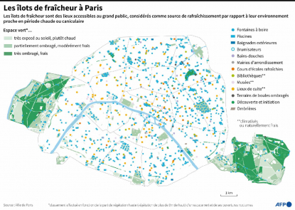
Within a city like Paris, for example, some of the more urbanised areas are warmer than others. According to Albergel, “with this satellite data, we can create urban heatmaps… and thereby intervene in a targeted way, by installing green spaces (trees or shade structures) or blue ones (fountains) that have a cooling effect on the most vulnerable zones.”
He said that satellite observations can also make it possible to follow the effects of adaptation measures to climate change.
“Impact in terms of thermal comfort for residents, but also the economic impact: investment of a certain amount of euros enables us to improve the thermal comfort of this or that zone in Paris by reducing temperatures,” he added.
Bénédicte REY
AFP France
Translation : Anna Maria JAKUBEK

- Home
- About AFP
- How we work
- Editorial & Ethical standards
- Fact-Checking Stylebook
- Meet the team
- Training
- Subscribe
- Contact
- Corrections
Copyright © AFP 2017-2023. All rights reserved. Users can access and consult this website and use the share features available for personal, private, and non-commercial purposes. Any other use, in particular any reproduction, communication to the public or distribution of the content of this website, in whole or in part, for any other purpose and/or by any other means, without a specific licence agreement signed with AFP, is strictly prohibited. The subject matter depicted or included via links within the Fact Checking content is provided to the extent necessary for correct understanding of the verification of the information concerned. AFP has not obtained any rights from the authors or copyright owners of this third party content and shall incur no liability in this regard. AFP and its logo are registered trademarks.
